Columbia River Estuary Study Taskforce
  • About
    • Our Approach
    • The CREST Story >
      • Background | CREST
      • Origins of CREST
      • CREST's Current Vision
    • Team >
      • Objectives
      • Denise Lofman
      • Jason Smith
      • Jess Hoch
      • Jay Horita
      • Zach Bigelow
      • Kyle Purdy
      • Narayan Elasmar
      • Garrett Phillips
      • Robert Henicksman
      • Mandy Flaitz
      • Becky Onsgaard
    • In The News
  • Services
    • Restoration Planning & Implementation
    • Ecosystem Research & Monitoring
    • Environmental Planning & GIS Mapping
    • Wetland Delineations & Assessments
    • Resource Library >
      • Available Documents
  • CREST Projects
    • Reach A, Coastal Lowlands Entrance >
      • Colewort Creek Wetland Enhancement
      • Fee-Simon Wetland Enhancement
      • Ft Columbia Tidal Reconnection
      • Hungry Harbor
      • Megler Creek
      • Otter Point Estuarine Restoration
      • West Sand Island
    • Reach B, Coastal Uplands Salinity Gradient >
      • Bear, Mary's, and Ferris Creeks
      • Gnat Creek Wetland Enhancement
      • Harlow Creek
      • Karlson Island Wetland Enhancement
      • South Tongue Point Wetland
    • Reach D, Western Cascades Tributary Confluences >
      • Dibblee Point Wetland Restoration
    • Reach E, Tidal Flood Plain Basin Constriction
    • Reach F, Middle Tidal Flood Plain Basin >
      • 3-Finger Jack Restoration
      • Bridge at Buckmire Slough
      • Crane Wetlands Restoration
      • Deep/Widgeon Restoration
      • Domeyer Wetlands Restoration
      • Flights End Restoration
      • McCarthy Creek Restoration
      • Millionaire Lake Restoration
      • Ruby Lake Restoration
      • South Bachelor Island Restoration
      • South Slough Restoration
      • Sturgeon Lake/Dairy Creek Restoration
      • Willow Bar Restoration
    • Reach G, Upper Tidal Flood Plain Basin >
      • Government Island Restoration
  • Partnerships
    • CREST Members >
      • Oregon Members
      • Washington Members
    • CREST Partners >
      • Bonneville Power Administration
      • Columbia Land Trust
      • Lewis & Clark National Historic Park
      • Lower Columbia Estuary Partnership
      • National Oceanic & Atmospheric Administration
      • North Coast Land Conservancy
      • North Coast Watershed Association
      • OR Department of State Lands
      • OR Department of Fish & Wildlife
      • OR Watershed Enhancement Board
      • PC Trask & Associates
      • US Army Corp of Engineers
      • USDA Natural Resources Conservation Service
      • US Fish & Wildlife Service
      • WA Dept of Fish & Wildlife
      • WA Dept of Natural Resources
      • WA Dept of Transportation
      • West Multnomah Soil & Water Conservation District
  • Contact
    • RFP's
    • Meetings
    • Employment

Megler Creek

Location: Megler Creek
Design Budget: $151,000 Construction Budget: $972,054
Start date: November, 2016
End date: February, 2017
Objective: Megler Creek Restoration is one part of the Columbia-Pacific Passage Habitat Restoration Project, a multi-phase project sponsored by CREST​ involving three separate tributaries to the Columbia River estuary.

Location of Project

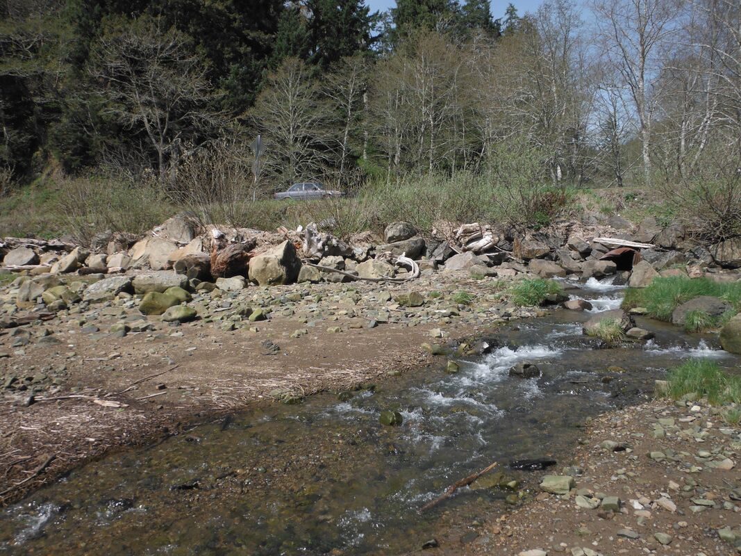
The three sites are located within 7 miles of each other on the Columbia River shoreline in southwest Washington. The three sites of this large-scale restoration effort include Fort Columbia, which was restored in 2010 as part of Phase I of the project, Megler Creek, which was restored last winter (Nov 16-February17) as part of Phase II, and Hungry Harbor, which will be constructed during the third and final phase of the restoration strategy. Restoration is needed within this estuarine reach of the Columbia River because extensive historical alterations of the shoreline have eliminated the majority of off-channel foraging and rearing opportunities along this important migration corridor. Almost the entire lower river shoreline in Washington from Knappton Cove to the town of Chinook is riprapped to protect State Route 401 and Highway 101.  As a result, most of the historical estuarine tributaries that once served as off-channel habitat for migrating and spawning salmon have been disconnected from the Columbia mainstem by inappropriately sized and placed culverts. Fish presence studies conducted by NOAA on the Columbia River mainstem indicate that the North Channel is the primary route taken by outgoing juvenile salmonids in the Columbia River system. Therefore, reconnecting off-channel rearing habitat necessary for migrating salmonids along this widely used route is vitally important for improving salmonid survival for ESA listed fishes in the Estuary.
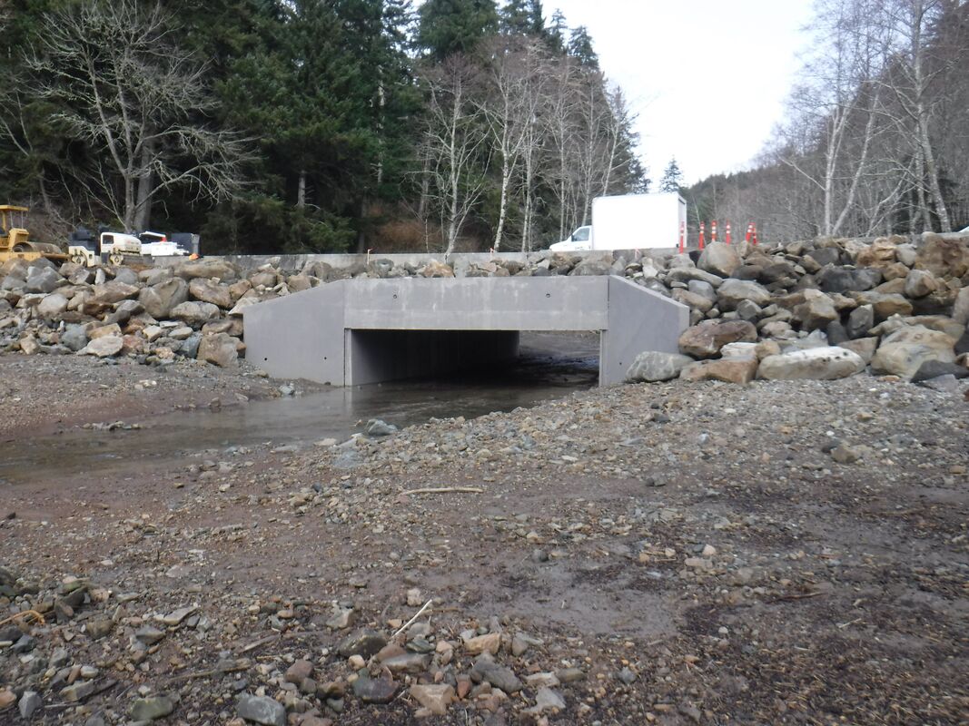
The Megler Creek project involves the replacement of an undersized 48-inch diameter corrugated metal pipe culvert, located beneath SR 401, with a concrete box culvert (25-foot span, 10-foot rise, 65-feet long). In addition to the removal of a fish passage barrier the project restored nearly 300 linear feet of Megler Creek to its historic estuarine condition. Restoration actions consisted of the excavation of accreted materials to pre-disturbance elevation and gradients, placement of large wood habitat structures, and extensive native plantings along Megler Creek.
The complete list of project partners and funders includes:
  • Bonneville Power Administration
  • NPS - Lewis and Clark National Historic Park
  • Washington Department of Transportation
  • Washington Department of Natural Resources​

  • Lower Columbia Fish Recovery Board
  • Salmon Recovery Funding Board
  • Pacific Marine & Estuarine Fish Habitat Partnership
  • US Fish and Wildlife Service
Pre-Restoration
Creek Enhancement
Post Restoration
CREST's mission is to provide locally-based, high quality environmental planning, habitat restoration, and research services to the Columbia-Pacific Region."

Picture
© Copyright 2020 CREST - Designed by Ham It Up Strategies 
Columbia River Estuary Study Taskforce
​818 Commercial Street, Suite 203
Astoria, Oregon  97103
503-325-0435
Fax 503-325-0459
Site Directory
  • About
    • Our Approach
    • The CREST Story >
      • Background | CREST
      • Origins of CREST
      • CREST's Current Vision
    • Team >
      • Objectives
      • Denise Lofman
      • Jason Smith
      • Jess Hoch
      • Jay Horita
      • Zach Bigelow
      • Kyle Purdy
      • Narayan Elasmar
      • Garrett Phillips
      • Robert Henicksman
      • Mandy Flaitz
      • Becky Onsgaard
    • In The News
  • Services
    • Restoration Planning & Implementation
    • Ecosystem Research & Monitoring
    • Environmental Planning & GIS Mapping
    • Wetland Delineations & Assessments
    • Resource Library >
      • Available Documents
  • CREST Projects
    • Reach A, Coastal Lowlands Entrance >
      • Colewort Creek Wetland Enhancement
      • Fee-Simon Wetland Enhancement
      • Ft Columbia Tidal Reconnection
      • Hungry Harbor
      • Megler Creek
      • Otter Point Estuarine Restoration
      • West Sand Island
    • Reach B, Coastal Uplands Salinity Gradient >
      • Bear, Mary's, and Ferris Creeks
      • Gnat Creek Wetland Enhancement
      • Harlow Creek
      • Karlson Island Wetland Enhancement
      • South Tongue Point Wetland
    • Reach D, Western Cascades Tributary Confluences >
      • Dibblee Point Wetland Restoration
    • Reach E, Tidal Flood Plain Basin Constriction
    • Reach F, Middle Tidal Flood Plain Basin >
      • 3-Finger Jack Restoration
      • Bridge at Buckmire Slough
      • Crane Wetlands Restoration
      • Deep/Widgeon Restoration
      • Domeyer Wetlands Restoration
      • Flights End Restoration
      • McCarthy Creek Restoration
      • Millionaire Lake Restoration
      • Ruby Lake Restoration
      • South Bachelor Island Restoration
      • South Slough Restoration
      • Sturgeon Lake/Dairy Creek Restoration
      • Willow Bar Restoration
    • Reach G, Upper Tidal Flood Plain Basin >
      • Government Island Restoration
  • Partnerships
    • CREST Members >
      • Oregon Members
      • Washington Members
    • CREST Partners >
      • Bonneville Power Administration
      • Columbia Land Trust
      • Lewis & Clark National Historic Park
      • Lower Columbia Estuary Partnership
      • National Oceanic & Atmospheric Administration
      • North Coast Land Conservancy
      • North Coast Watershed Association
      • OR Department of State Lands
      • OR Department of Fish & Wildlife
      • OR Watershed Enhancement Board
      • PC Trask & Associates
      • US Army Corp of Engineers
      • USDA Natural Resources Conservation Service
      • US Fish & Wildlife Service
      • WA Dept of Fish & Wildlife
      • WA Dept of Natural Resources
      • WA Dept of Transportation
      • West Multnomah Soil & Water Conservation District
  • Contact
    • RFP's
    • Meetings
    • Employment