Columbia River Estuary Study Taskforce
  • About
    • Our Approach
    • The CREST Story >
      • Background | CREST
      • Origins of CREST
      • CREST's Current Vision
    • Team >
      • Objectives
      • Denise Lofman
      • Tom Josephson
      • Jason Smith
      • Tracy Hruska
      • April Silva
      • Narayan Elasmar
      • Paula Gerttula
      • Robert Henicksman
      • Mandy Flaitz
      • Garrett Phillips
    • In The News
  • Services
    • Restoration Planning & Implementation
    • Ecosystem Research & Monitoring
    • Environmental Planning & GIS Mapping
    • Wetland Delineations & Assessments
    • Resource Library >
      • Available Documents
  • CREST Projects
    • Reach A, Coastal Lowlands Entrance >
      • Colewort Creek Wetland Enhancement
      • Fee-Simon Wetland Enhancement
      • Ft Columbia Tidal Reconnection
      • Hungry Harbor
      • Megler Creek
      • Otter Point Estuarine Restoration
      • West Sand Island
    • Reach B, Coastal Uplands Salinity Gradient >
      • Bear, Mary's, and Ferris Creeks
      • Gnat Creek Wetland Enhancement
      • Harlow Creek
      • Karlson Island Wetland Enhancement
      • South Tongue Point Wetland
    • Reach D, Western Cascades Tributary Confluences >
      • Dibblee Point Wetland Restoration
    • Reach E, Tidal Flood Plain Basin Constriction
    • Reach F, Middle Tidal Flood Plain Basin >
      • 3-Finger Jack Restoration
      • Bridge at Buckmire Slough
      • Crane Wetlands Restoration
      • Deep/Widgeon Restoration
      • Domeyer Wetlands Restoration
      • Flights End Restoration
      • McCarthy Creek Restoration
      • Millionaire Lake Restoration
      • Ruby Lake Restoration
      • South Bachelor Island Restoration
      • South Slough Restoration
      • Sturgeon Lake/Dairy Creek Restoration
      • Willow Bar Restoration
    • Reach G, Upper Tidal Flood Plain Basin >
      • Government Island Restoration
  • Partnerships
    • CREST Members >
      • Oregon Members
      • Washington Members
    • CREST Partners >
      • Bonneville Power Administration
      • Columbia Land Trust
      • Lewis & Clark National Historic Park
      • Lower Columbia Estuary Partnership
      • National Oceanic & Atmospheric Administration
      • North Coast Land Conservancy
      • North Coast Watershed Association
      • OR Department of State Lands
      • OR Department of Fish & Wildlife
      • OR Watershed Enhancement Board
      • PC Trask & Associates
      • US Army Corp of Engineers
      • USDA Natural Resources Conservation Service
      • US Fish & Wildlife Service
      • WA Dept of Fish & Wildlife
      • WA Dept of Natural Resources
      • WA Dept of Transportation
      • West Multnomah Soil & Water Conservation District
  • Contact
    • RFP's

Ft Columbia Tidal Reconnection

Location: Fort Columbia State Park, Chinook WA
Objective: Reconnect 96 acre wetland to full tidal influence through the installation of a new 12 feet by 12 feet culvert through Hwy 101.

Project partners: 
Bonneville Power Administration
Lower Columbia Estuary Partnership
Lower Columbia Fish Recovery Board
RCO’s Salmon Recovery Funding Board
US Fish and Wildlife Service

Related services: 
Restoration Planning & Implementation

Location of Project


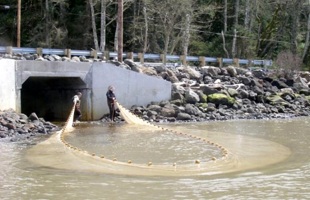
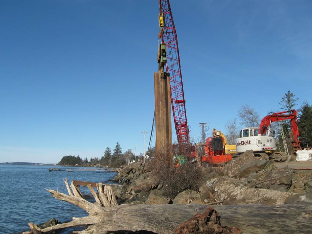
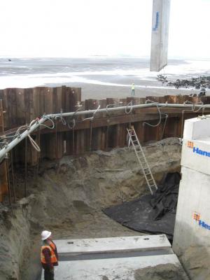
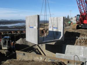
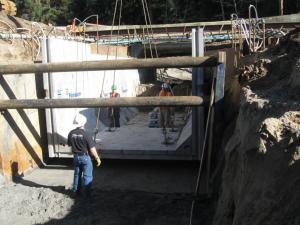
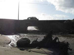
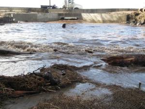
New Culvert Gives Salmon Access to Historic Tidal Marsh

Juvenile salmon gain access to more rearing habitat in the Columbia River thanks to the installation of an enormous culvert. The recently completed project reconnects a wetland with the tide waters of the Columbia River. The tidal wetland, noted on the maps of Lewis and Clark, was cut off from the river by a highway and railroad in the 1890s. The new culvert is located near Fort Columbia, east of Chinook, Washington and north of Astoria, Oregon. The video was produced and narrated by David Wilson.
CREST's mission is to provide locally-based, high quality environmental planning, habitat restoration, and research services to the Columbia-Pacific Region."

Picture
© Copyright 2020 CREST - Designed by Ham It Up Strategies 
Columbia River Estuary Study Taskforce
​818 Commercial Street, Suite 203
Astoria, Oregon  97103
503-325-0435
Fax 503-325-0459
Site Directory
  • About
    • Our Approach
    • The CREST Story >
      • Background | CREST
      • Origins of CREST
      • CREST's Current Vision
    • Team >
      • Objectives
      • Denise Lofman
      • Tom Josephson
      • Jason Smith
      • Tracy Hruska
      • April Silva
      • Narayan Elasmar
      • Paula Gerttula
      • Robert Henicksman
      • Mandy Flaitz
      • Garrett Phillips
    • In The News
  • Services
    • Restoration Planning & Implementation
    • Ecosystem Research & Monitoring
    • Environmental Planning & GIS Mapping
    • Wetland Delineations & Assessments
    • Resource Library >
      • Available Documents
  • CREST Projects
    • Reach A, Coastal Lowlands Entrance >
      • Colewort Creek Wetland Enhancement
      • Fee-Simon Wetland Enhancement
      • Ft Columbia Tidal Reconnection
      • Hungry Harbor
      • Megler Creek
      • Otter Point Estuarine Restoration
      • West Sand Island
    • Reach B, Coastal Uplands Salinity Gradient >
      • Bear, Mary's, and Ferris Creeks
      • Gnat Creek Wetland Enhancement
      • Harlow Creek
      • Karlson Island Wetland Enhancement
      • South Tongue Point Wetland
    • Reach D, Western Cascades Tributary Confluences >
      • Dibblee Point Wetland Restoration
    • Reach E, Tidal Flood Plain Basin Constriction
    • Reach F, Middle Tidal Flood Plain Basin >
      • 3-Finger Jack Restoration
      • Bridge at Buckmire Slough
      • Crane Wetlands Restoration
      • Deep/Widgeon Restoration
      • Domeyer Wetlands Restoration
      • Flights End Restoration
      • McCarthy Creek Restoration
      • Millionaire Lake Restoration
      • Ruby Lake Restoration
      • South Bachelor Island Restoration
      • South Slough Restoration
      • Sturgeon Lake/Dairy Creek Restoration
      • Willow Bar Restoration
    • Reach G, Upper Tidal Flood Plain Basin >
      • Government Island Restoration
  • Partnerships
    • CREST Members >
      • Oregon Members
      • Washington Members
    • CREST Partners >
      • Bonneville Power Administration
      • Columbia Land Trust
      • Lewis & Clark National Historic Park
      • Lower Columbia Estuary Partnership
      • National Oceanic & Atmospheric Administration
      • North Coast Land Conservancy
      • North Coast Watershed Association
      • OR Department of State Lands
      • OR Department of Fish & Wildlife
      • OR Watershed Enhancement Board
      • PC Trask & Associates
      • US Army Corp of Engineers
      • USDA Natural Resources Conservation Service
      • US Fish & Wildlife Service
      • WA Dept of Fish & Wildlife
      • WA Dept of Natural Resources
      • WA Dept of Transportation
      • West Multnomah Soil & Water Conservation District
  • Contact
    • RFP's